gisprojects
Custom Basemap Using Google
Customizing a basemap can be done in multiple ways. Previously, I used ArcGIS Esri software to do this. However, what if the client does not have a license?
Purpose: Customize a basemap to the stylistic colors of an organization.
Step 1: Chose an organization.
I chose the non-profit Global Links. They do good work that has local and far reaching impact - for example, they are a primary mask supplier for an organization I volunteer with.
Step 2: Create a color pallet.
To get a reference image, I took a screen shot of the main page of Global Links.

Created a color pallet reference table with a Column for the Hex Code, Color Name, Sample Image, and RBG Distribution. The below reference table was used as a code pallet for which hex codes to use to assign colors in the map style editor.
Abbreviated Color Pallet Example
|
Hex Code |
Color Name |
Color |
RBG Color Code |
|
#8C264B
|
Stiletto |
|
R: 140 |
|
B: 38 |
|||
|
G: 75 |
|||
#04B2D9
|
Cerulean |
|
R: 4 |
|
B: 178 |
|||
|
G: 217 |
|||
#03738C
|
Blue Lagoon |
|
R: 3 |
|
B: 115 |
|||
|
G: 140 |


Step 3: Create basemap with color pallet.
I used the Google Sytling Wizard to create a custom basemap with colors pulled from my reference pallet table.
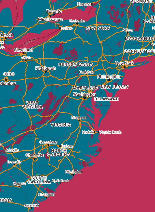
I also created a table that documented the colors changed for each section.
Colors Used For Map Features
| Feature Type |
Element Type |
Styler |
|
All |
Geometry |
Mosque (#026873)
|
|
All |
Labels |
Aubergine (#260911)
|
|
Landscape |
Geometry |
Mosque (#026873)
|
|
Administrative |
Geometry |
Wine Berry (#591830)
|
|
Administrative/Land parcel |
Stroke |
Cerulean (#04B2D9)
|
|
Administrative/Land parcel |
Labels/Text fill |
Aubergine (#260911)
|
|
Landscape/Natural |
Geometry |
Blue Lagoon (#03738C)
|
|
Points of Interest |
Geometry |
Stiletto (#8C264B) |
|
Points of Interest |
Labels/Text Fill |
Aubergine (#260911)
|
|
Park |
Geometry |
Stiletto (#8C264B) |
|
Park |
Labels/Text Fill |
Aubergine (#260911) |
|
Road |
Geometry |
Concrete (#F2F2F2)
|
|
Road/Highway |
Geometry |
Carrot Orange (#F2911B) |
|
Road/Highway |
Stroke |
Korma (#8C6111)
|
|
Road/Highway/Controlled area |
Geometry |
Carrot Orange (#F2911B) |
|
Road/Highway/Controlled area |
Stroke |
Korma (#8C6111)
|
|
Road/Artery |
Geometry |
Concrete (#F2F2F2)
|
|
Road/Local |
Text fill |
Cioccolato (#59360A)
|
|
Transit/Line |
Geometry |
Brick Red (#BF3056) |
|
Transit/Line |
Label/Text Fill |
Wine Berry (#591830)
|
|
Transit/Line |
Label/Text Outline |
Concrete (#F2F2F2)
|
|
Transit/Station |
Geometry |
Stiletto (#8C264B) |
|
Water |
Geometry |
Brick Red (#BF3056)
|
Export JSON, create API, and share the map.
I exported the JSON file containing the map color coding and created a Google Map API. Then, I used the API and reference code to create an interactive webpage version of the map.
Check out the interactive version of my custom Map Style for Global Links on the map page!